Environmental Protection (Water and Wetland Biodiversity) Policy 2019
Background
The purpose of the Environmental Protection (Water and Wetland Biodiversity) Policy 2019 (EPP Water and Wetland Biodiversity) is to achieve the object of the Environmental Protection Act 1994 (EP Act) in relation to waters and wetlands. That is, protecting Queensland’s water environment while allowing for development that is ecologically sustainable.
Environmental values (EVs) and water quality objectives (WQOs) are being progressively determined for Queensland waters. EVs define the uses of the water by aquatic ecosystems and for human uses (e.g. drinking water, irrigation, aquaculture, recreation). WQOs define objectives for the physical, chemical and biological characteristics of the water (e.g. nitrogen content, dissolved oxygen, turbidity, toxicants, fish). Please see the fact sheet for more detail.
The management intent for waters is stated in section 15 of the EPP Water and Wetland Biodiversity. For waters of high ecological value the water quality is to be maintained. For slightly disturbed waters, the water quality is to be improved where needed, to achieve the WQOs. For moderately disturbed waters, water quality is to be maintained, or improved where needed, to meet the WQOs. In highly disturbed waters, water quality is to be improved so that it achieves the WQOs.
As EVs and WQOs are established for Queensland waters in accordance with the EPP Water and Wetland Biodiversity, after approval they are included in Schedule 1. For waters not included in Schedule 1, the EVs and WQOs are respectively determined in accordance with section 6 and section 11 of the EPP Water and Wetland Biodiversity.
The Australian and New Zealand Guidelines for Fresh and Marine Water Quality (ANZG, 2018) includes a management framework that has been adopted in the EPP Water and Wetland Biodiversity.
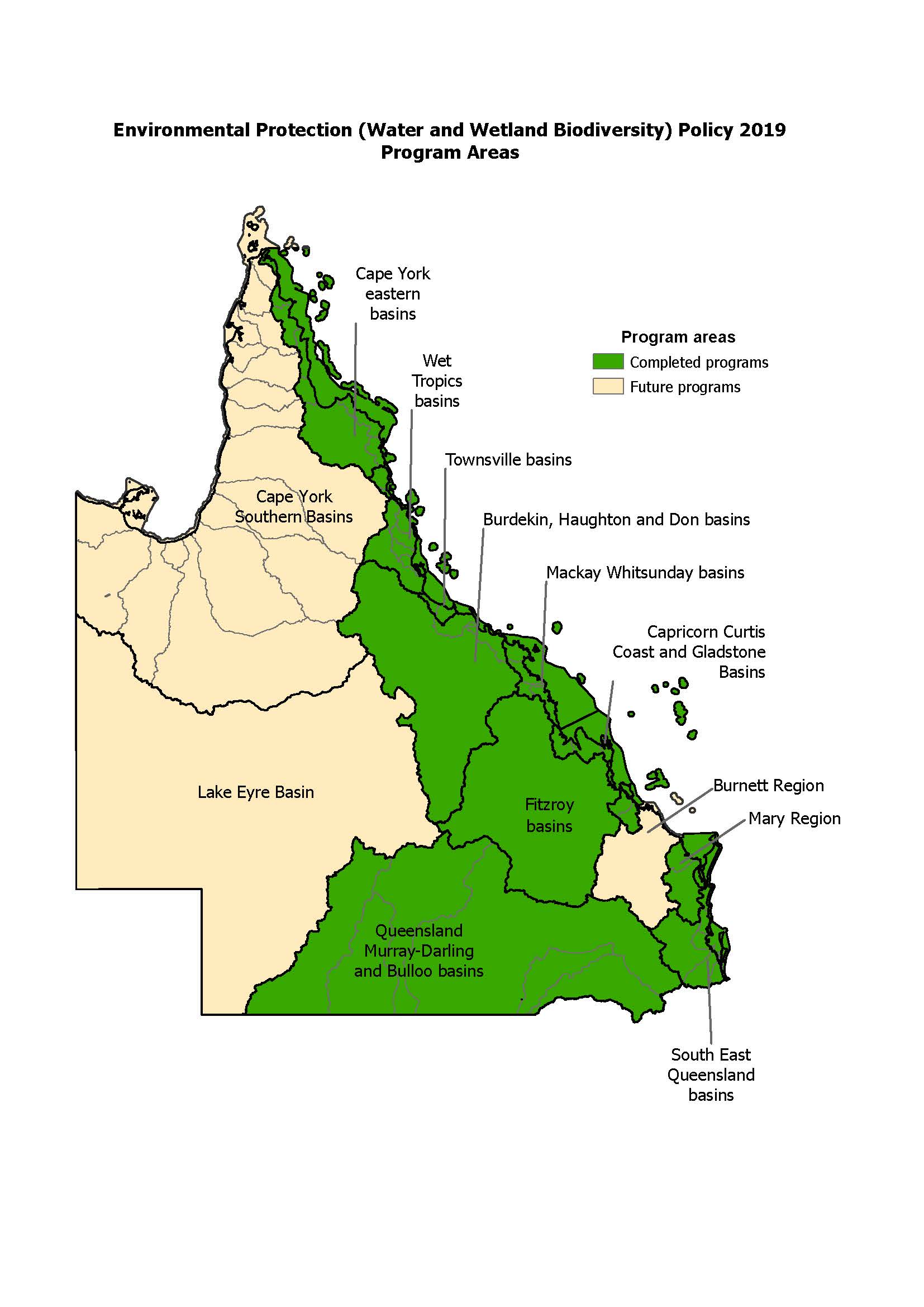
EPP (Water and Wetland Biodiversity) Schedule 1 documents and mapping
EPP (Water and Wetland Biodiversity) Schedule 1 documents and maps are available from the list of basins on the drop -down menu on the left side of this page. Also refer to the following status maps:
- Interactive map of EPP (Water and Wetland Biodiversity) scheduled data – surface water
To display the layers please follow these steps from within Queensland Globe: 1: click on ‘Layers’ in the left-hand panel. 2: Click on Add Layers‘. 3. Click on drop-down arrow to the right of the ‘Environment’ heading. 4. Scroll down to the ‘Water and wetland biodiversity’ heading and click on the drop-down arrow to the right of the heading. The schedule outline layer, environmental value zone layer, water type layer and management intent layer can all be clicked on and off from within this location. - Static map of EPP (Water and Wetland Biodiversity) scheduled data – surface water .
Schedule areas are predominantly based on Australia’s River Basins 1997 project. This was a joint state, territory, and Australian government initiative to create a national spatial database of major hydrological basins. The definition for ‘basin’ in the definition section of the EPP (Water and Wetland Biodiversity) refers to this data and map. Please note that Geoscience Australia periodically updates basin boundaries. When an area is scheduled under the EPP (Water and Wetland Biodiversity), the most recent dataset is used.
The basin boundary map can be downloaded from the Bureau of Meteorology website. Please note that Geoscience Australia is the custodian of the data.
In cases where inconsistencies may arise between the Schedule 1 Plan and data on Qld Globe, the Schedule 1 Plan has precedence. The EPP (Water and Wetland Biodiversity) data is filed in the ‘Environment’ Layers under ‘Water and wetland biodiversity’.
Spatial datasets and mapping methods
Spatial datasets for scheduled areas are available from the Queensland Spatial Catalogue, QSpatial. Search for ‘EPP’.
In cases where inconsistencies may arise between the Schedule 1 Plan and data on QSpatial, the Schedule 1 Plan has precedence.
The department has prepared a mapping procedural guide outlining the procedures taken in developing mapping under the EPP (Water and Wetland Biodiversity). The guide includes an explanation of mapping procedures for project area boundaries, EVs catchments, water types, and management intent.
Related information
- Environmental Protection (Water and Wetland Biodiversity) Policy 2019
- Environmental Protection Act 1994
- Queensland water quality guidelines
- National water quality management strategy
- Water monitoring and sampling manual
- Guideline: Deciding aquatic ecosystem indicators and local water quality guidelines under the Environmental Protection (Water and Wetland Biodiversity) Policy 2019
- Australian drinking water guidelines
- Australian and New Zealand guidelines for fresh and marine water quality
- Frequently asked questions
- Lyngbya (blue-green algae)
Contact details
For further information please contact the Healthy Waters Policy and Strategy Team:
- by email at evinfo@des.qld.gov.au
- by mail to the Healthy Waters Policy and Strategy Team at GPO Box 2454, Brisbane QLD 4001